
Updated September 29, 2026
CU Boulder South is about to change dramatically. Beginning the week of October 5, 2026, the entire site, including its existing trails, is scheduled to close to public access while the City of Boulder begins the South Boulder Creek Flood Mitigation Project. Construction is expected to take three to five years.
For South Boulder residents, that means losing a familiar recreation area for several years and potentially encountering construction-related bicycle or road detours. For homeowners and prospective buyers, the more consequential issue is what the project is designed to do: reduce flood risk for approximately 2,300 residents, 260 structures, and key transportation corridors including US 36 and Foothills Parkway.
The project may eventually change the mapped floodplain for some properties as well, but those changes are not final today. Here is what is known as of September 22, 2026, and what buyers should verify property by property.
CU Boulder South Will Fully Close Beginning the Week of October 5
The immediate change is straightforward: the entire CU Boulder South site will be off-limits to public recreation during construction.
The City of Boulder says construction is expected to begin the week of October 5, 2026, and the project is projected to take approximately three to five years. The closure includes CU-managed trails, so existing walking, running and dog-recreation access will not remain open in a limited or phased form.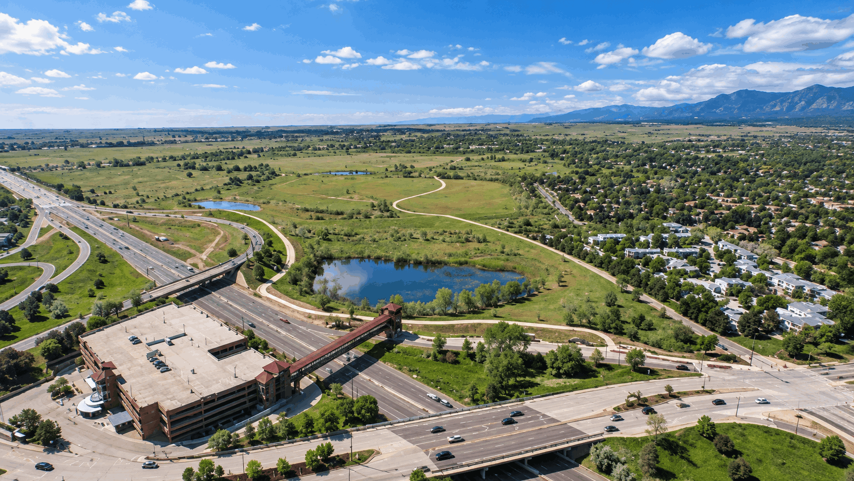
City staff evaluated whether portions of the property could stay accessible, but determined that public access could not be safely separated from construction. Flood-control work will occur toward the northern part of the site while environmental restoration and mitigation work will also occur farther south. Heavy equipment and construction vehicles will need to move throughout the property.
For people accustomed to walking dogs or using the site's informal recreation network, that is likely to be the most noticeable short-term change. The city specifically says hiking and dog walking will not be allowed on the property during construction and directs residents toward other city parks, on-leash trails, Voice and Sight areas, and dog parks.
Transportation impacts may also change as construction progresses. The city says its Cone Zones system will carry current information about road impacts and closures or detours affecting the US 36 Regional Bikeway. Buyers or residents who regularly bike through South Boulder should check those notices rather than assuming today's route will remain available throughout a multi-year construction project.
The Project Is Designed Around the Flood Risk Exposed in 2013
The closure is not primarily a university-development project. The construction beginning this fall is a City of Boulder flood-protection project focused on South Boulder Creek.
During the September 2013 Front Range flood, lower South Boulder Creek experienced flows the City of Boulder describes as being on the order of a 100-year flood, and water overtopped US 36. That created not only property risk but also a transportation and emergency-access problem because flooding can cut off an important entry and exit route for Boulder.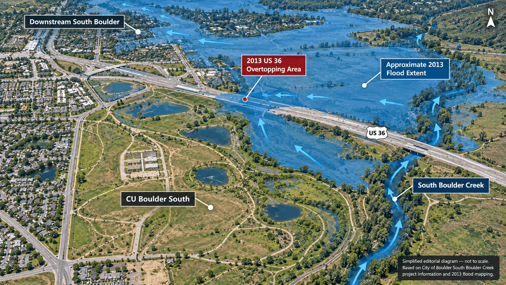
A "100-year flood" is easy to misunderstand. It does not mean flooding should occur only once every century. In regulatory floodplain terminology, the 100-year flood generally refers to a flood with a 1% chance of occurring in any given year. FEMA refers to this as the one-percent-annual-chance flood.
The South Boulder Creek project is intended to temporarily hold back part of that floodwater before allowing it to move downstream in a controlled way. The city identifies the project as its highest-priority flood mitigation project and says the completed infrastructure is intended to benefit approximately 2,300 residents and 260 structures, while improving protection for US 36 and Foothills Parkway.
That distinction matters when discussing South Boulder real estate. A creek may appear calm during a showing in August or September, but a property's flood exposure cannot be judged visually. Buyers should use current regulatory mapping, elevation information where applicable, past property records and insurance information rather than simply estimating risk from distance to the creek.
What Boulder Is Actually Building at CU Boulder South
This is a large civil-engineering and ecological-restoration project, not simply a new berm beside the creek.
According to the City's current project description, construction includes:
- An earthen flood detention dam along the northern and western portions of the CU Boulder South site
- A concrete spillway along US 36
- An outlet tunnel beneath US 36
- A groundwater-management system
- Removal of existing structures including the warehouse and tennis courts
- Reconstruction of South Loop Drive for future access
- Vegetation clearing and ecological restoration
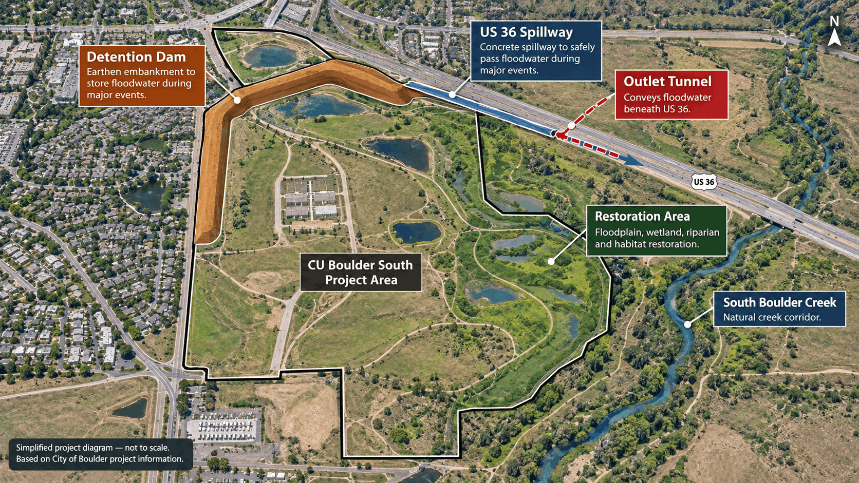
During a major flood, the detention area is intended to temporarily store water and release it more safely downstream rather than allowing the same volume to overtop US 36. The design therefore addresses both nearby flood exposure and the ability to maintain a critical transportation route during an emergency.
The project also has a substantial environmental component. The city says restoration work is intended to preserve and improve wetlands and riparian habitat and account for protected species including the Preble's meadow jumping mouse and Ute ladies'-tresses orchid. As part of the broader agreement between CU Boulder and the city, 119 acres are slated for restoration and management as city open space.
The currently estimated project cost is approximately $76.5 million, funded through the City of Boulder Storm and Flood Utility in partnership with the Mile High Flood District. The city's September 2026 FAQ lists approximately $69.48 million for construction, $2.80 million for engineering and $4.08 million for property acquisition.
The City also states that the design has gone through review involving the Colorado State Engineer's Office Dam Safety Branch, Colorado Department of Transportation and Federal Highway Administration, while FEMA and its consultant reviewed the proposed floodplain changes. The City reports that required project permits and approvals have been received.
Some South Boulder Properties Could Eventually Leave the Mapped Floodplain
For homeowners and buyers, this is the part of the project that requires the most careful wording: proposed floodplain changes exist, but they are not yet final.
As of September 22, 2026, the City estimates that approximately 260 properties may be removed from the floodplain as a result of the completed project. The City has notified affected property owners and provides an address-searchable proposed floodplain map.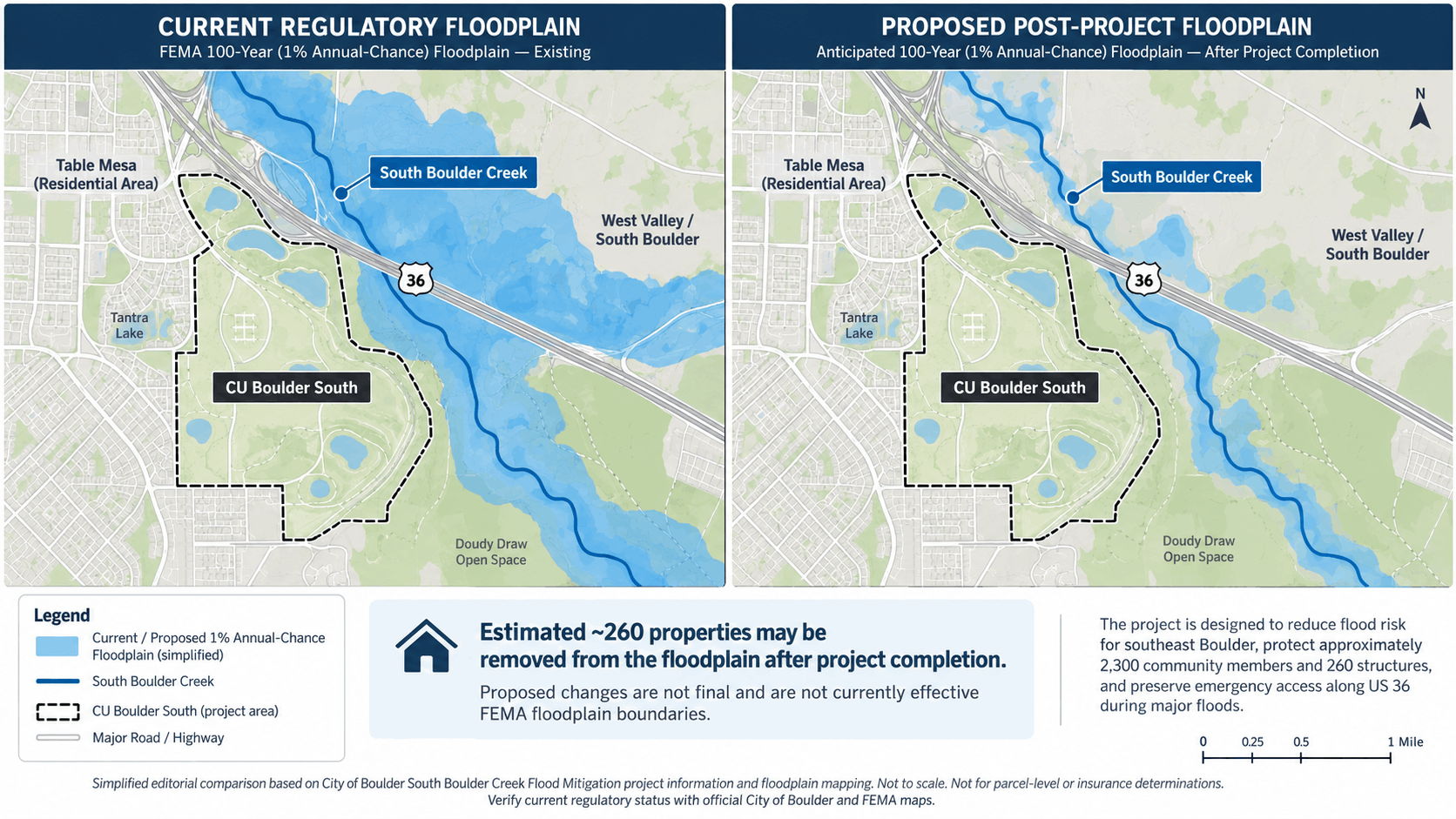
However, the City's project page specifically cautions:
Floodplain changes are proposed and will not be finalized until project completion.
That sentence is particularly important in a real-estate transaction.
A buyer should not treat a proposed future boundary as though the property has already been officially remapped. Current floodplain designation, current lender requirements and current insurance conditions remain the appropriate starting point until applicable mapping changes take effect.
FEMA defines a Letter of Map Revision, or LOMR, as an official revision to an existing National Flood Insurance Program map showing changes to floodplains, regulatory floodways or flood elevations.
For properties in a FEMA Special Flood Hazard Area, federal rules generally require flood insurance when the structure secures a mortgage from a federally regulated or insured lender. A lender can also impose its own insurance requirements outside those mapped areas.
The city says some properties removed from the floodplain could see lower risk and possible lower insurance premiums. That should not be read as a promise of a specific premium reduction. Insurance pricing depends on the property, coverage, insurer, policy characteristics and the mapping effective when the quote is issued.
For a South Boulder purchase, check the exact address against the City's current floodplain map and FEMA information, then obtain a property-specific insurance quote. If the parcel appears on the City's proposed post-project map, treat that as additional context rather than a substitute for the currently effective designation.
Homebuyers Should Separate Construction Impacts From Long-Term Flood Risk
A house can be close to this project without having the same issues as another home a few blocks away. Address-level due diligence matters more than a general "South Boulder" label.
During the construction period, buyers near CU Boulder South should consider at least three separate questions.
First is daily construction exposure. The entire CU South property will be active over multiple years, but the location and intensity of work will move as different portions of the project are built. A serious buyer should visit the property during the day and review current city construction notices rather than assume today's conditions represent the entire project timeline.
Second is recreation and transportation access. A listing may advertise proximity to CU Boulder South or a nearby trail connection based on conditions that existed before October 2026. Because the site will be fully closed, buyers should identify the alternative trails, bike routes and open spaces they would actually use. If the US 36 Regional Bikeway is part of a commute, monitor current construction detours.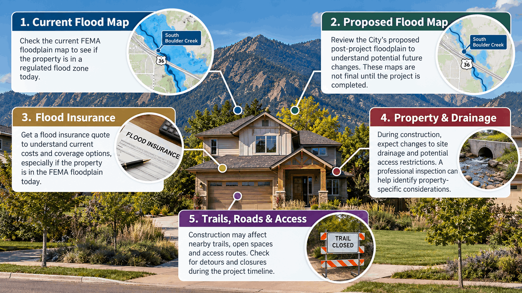
Third is property-specific flood exposure. Check:
- The currently effective floodplain designation
- The City's proposed post-project floodplain map
- Available elevation certificates or flood-related property records
- Existing flood insurance and a current buyer-specific insurance quote
- Drainage, grading, groundwater and any known history of water intrusion at the individual property
- Applicable floodplain restrictions if future additions or significant improvements are part of the purchase plan
The City of Boulder maintains address-searchable floodplain resources and can provide formal property floodplain information. Its mapping page emphasizes that floodplain maps are used for management, regulation and insurance requirements and are periodically revised to account for mitigation improvements, new studies and changing conditions.
None of this means buyers should assume that a property currently in a floodplain is unsuitable, or that a property outside one carries no flood risk. The purpose of the review is to understand the actual conditions, costs, insurance requirements and development constraints of the specific address before the contingency deadlines in a contract.
What Happens After the Flood Project Is Finished?
Completion of the flood project will not simply reopen CU Boulder South exactly as it exists today. The site is entering a longer-term transition involving restored open space and eventual university planning.
The City's current project schedule lists construction from 2026 through 2031, although the public construction estimate remains three to five years. The exact reopening timeline will depend on construction progress and restoration work.
The 119 acres being restored as city open space will go through a future planning process. The City says decisions about visitor use of that future open-space acreage have not yet been made, so residents should not assume today's trail configuration will return unchanged when construction ends.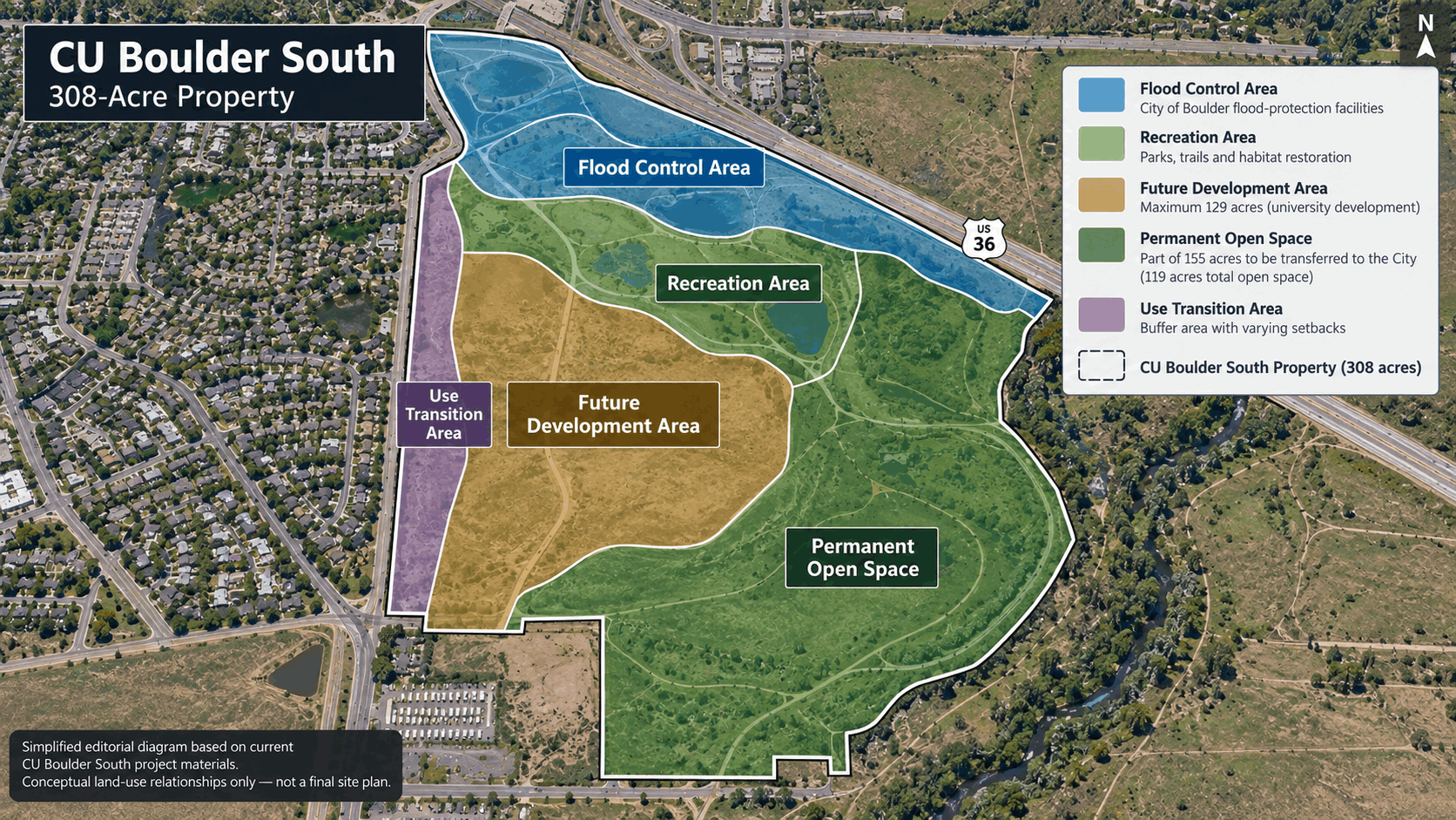
The remainder of CU Boulder South also has a longer-term future. The site totals approximately 308 acres, and the annexation agreement allows university development on a maximum of 129 acres. CU Boulder says site planning for that developable portion has not yet begun, and university construction cannot begin until the City's flood-protection project is completed. The university currently says the earliest construction is likely around 2030, subject to completion of the flood work and future planning.
That means South Boulder buyers should distinguish between what is definite today and what remains future planning:
The October 2026 site closure is definite. The major flood infrastructure is defined. Proposed floodplain changes have been modeled. But the precise post-construction visitor experience and the detailed layout of future CU Boulder development are not settled.
For a homeowner, seller or buyer, the practical approach is to monitor the project without making assumptions about future property values, premiums, views or development impacts. Those questions depend on the specific property and on decisions that may occur years from now.
If you are considering a home in South Boulder, Table Mesa, Shanahan Ridge or another area near South Boulder Creek, Eric can help you compare specific properties in the context of current flood mapping, construction access, trails, transportation and the area's longer-term plans. Online project maps are useful screening tools, but they cannot replace reviewing the actual property, disclosures, inspection findings, permits, insurance quote, flood information, HOA documents where applicable and contract terms before making a purchase decision.
FROM OUR BLOG

Pearl Street Mall Guide: Where to Eat, Shop, and People-Watch
Pearl Street Mall is one of the easiest places to start understanding Boulder, but there is an important distinction first-time visitors often miss: the pedestrian mall itself is only four blocks, from 11th Street to 15th Street. Downtown shopping and dining continue east and west well beyond those

Boulder Without a Car: Walkable, Bikeable, and Transit-Friendly Things to Do
If you are considering Boulder without a car, the useful question is not simply, “Is Boulder walkable?” It is whether the places you actually use can be connected comfortably by walking, biking, and transit from a specific address. Boulder gives car-free and car-light residents more infrastructure t

Best Places to Stay in Boulder by Travel Style
Choosing where to stay in Boulder is less about finding one universally “best” hotel and more about matching your lodging to what you actually plan to do. A downtown stay makes it easier to walk to Pearl Street restaurants and shops. A cottage at Chautauqua puts hiking outside your door. A suite wit